It’s been a snowy, blustery and bone-chilling winter for many Canadians. British Columbians were digging out of abnormal snow in early March. The Prairies have seen a good dose of good old-fashioned winter, and extreme cold warnings were issued in Ontario, Quebec and the Atlantic provinces as well. Then there was the Christmas travel period thrown into chaos by winter storms – a huge mess from coast to coast.

One thing that points to all that cold weather is La Niña. It’s a climate pattern that results in cooler ocean waters building up off the coast of Ecuador and Peru. That sets off a change to atmospheric conditions further north, resulting in cooler air over the west coast of North America, and drier air in the southern United States.
La Niña is a climate phenomenon that results in changes to atmospheric conditions often leading to cooler temperatures in western Canada.
National Oceanic and Atmospheric Administration (NOAA)
Now, that period of cooling is weakening, which could usher in a prolonged period of extreme heat – possibly even pushing average global temperatures past that all-important threshold of 1.5 C beyond which, scientists fear, the planet will cross irreversible tipping points.
12
The effects of La Niña can be seen in the equatorial Pacific on March 2, 2022, in terms of a large expanse of cooler-than-normal waters.
Environment and Climate Change Canada
22
The effects of La Niña have clearly dissipated in this image from March 7, 2023.
Environment and Climate Change Canada
What is La Niña?
La Niña is a climate phenomenon that results in cooler-than-normal waters appearing off the coast of South America, near Ecuador and Peru.
La Niña occurs when stronger trade winds push warm water away from South America and toward Australia and Indonesia across the equatorial Pacific Ocean, which leaves a buildup (or upwelling) of cold water.
That cooler air inhibits cloud formation, and rain, in the eastern Pacific near South America. It also generates a lot of rain in the western Pacific over Indonesia. Those anomalies push the jet stream – high-altitude bands of fast-flowing air that control the weather – further north. Changes in atmospheric conditions have a spillover effect on weather patterns over North America that can last for months.
La Niña is usually associated with a period of cooler temperatures, especially in Western Canada, says Bill Merryfield, a research scientist with Environment Canada’s climate modelling office. He says La Niña’s chilling effect might have tempered the wildfire season in B.C. last year.
Read more:
Why has B.C.’s spring been so cold and wet?
But the impacts can be felt even months after La Niña starts to dissipate, which has already started. Because of those lingering effects, Merryfield says Environment Canada is predicting a cooler spring on the west coast of Canada. But that doesn’t mean we aren’t in store for much more heat in the not-so-distant future.
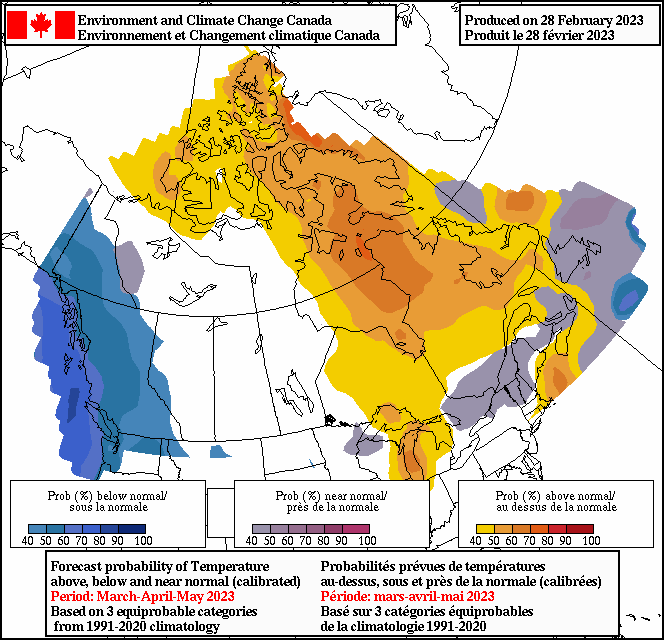
Environment and Climate Change Canada is forecasting a cooler spring on the west coast of Canada. One reason could be the lingering effects of La Niña.
Environment and Climate Change Canada
How long do La Niñas usually last?
La Niña’s ‘opposite’ is El Niño. It’s a period of warmer ocean water in the equatorial Pacific. The earliest recorded El Niño was in 1578. The warming phenomenon was first noticed by Ecuadorian and Peruvian fishermen around Christmas, hence the Spanish reference to the ‘Christ Child’ or ‘little boy.’ Decades later, when a cooling trend was routinely observed following El Niño, it was named La Niña, or ‘little girl.’
These two weather anomalies don’t happen on a regular basis, instead appearing every two to seven years. The last strong El Niño peaked in late 2015-early 2016, and before that in 1997-98. The last strong La Niña was in 2010-11.
El Niño and La Niña years since 1980.
Typically, El Niño and La Niña conditions start to appear around June and last for around nine months. They peak in December and continue all the way into the following spring.
But what makes the current cycle unusual is that La Niña conditions have persisted for three years in a row, beginning in 2020, a pattern not seen since the 1970s.
Tom Di Liberto, a climatologist with the U.S. National Oceanographic and Atmospheric Administration (NOAA), says “we’re currently in the midst of our third La Niña winter in a row.”
In his view, that pattern is highly unusual. “This is only the third time it’s happened” since official weather records started being kept.

There are clear indications that the current pattern of La Niña cooling is weakening. That means a return to neutral conditions and, very likely, the formation of La Niña’s opposite – El Niño, a period of warming – in late summer or in the fall.


In fact, climatologists are already starting to see that happen.
“You do actually see just a hint of El Niño starting to develop off the coast (of South America),” Merryfield says. “And our forecast does point to that developing over the next several seasons.”
The earliest indications of an El Niño (period of warming) are becoming apparent off the coast of Ecuador and Peru in South America.
Environment and Climate Change Canada
If La Niña goes away, how hot will things get?
In the near future, we can expect a protracted period of global heating. The developing El Niño could push temperatures up next winter and into 2024.
“Global temperatures tend to be higher in years with an El Niño, and particularly the year after the El Niño peaks,” Merryfield says. That’s what happened in 2016, the hottest year on record for the planet, which also came after a very strong El Niño the year before.
That means, according to Merryfield, a very good chance that 2024 will also be a record-breaker, especially as global warming continues to become more and more pronounced with increased greenhouse gas emissions accumulating in the atmosphere.
NOAA’s Di Liberto suggests El Niño will give global warming a “boost up.”
“If someone’s trying to dunk a ten-foot basket, and they’re getting about nine feet, El Niño is helping push it up that extra foot.”
What do these weather phenomena tell us about global warming?
It might seem that the presence of La Niña, associated with cooler temperatures, is a good thing when it comes to global warming, especially if there have been back-to-back La Niña cycles in a row, as has been the case over the past three years.
That is until you consider another stark reality, says Di Liberto: the past decade has experienced some of the warmest temperature averages on record, even with the clearer presence of La Niña, which is associated with cooler temperatures.
In other words, Earth has been shattering those temperature records, even with the planetary equivalent of a cold compress – La Niña – present.

Even the year 1998, which featured a very strong El Niño warming trend, comes nowhere close to matching some of the temperature records set in more recent La Niña years, despite its cooling effect. “The fact that (2022, a La Niña year) crushed (1998, an El Niño year) in terms of global temperature anomalies … just really indicates that our planet’s warming.”
Now, take the cooling effect of this year’s La Niña away, add in the warming effect of the upcoming El Niño, and all of a sudden you get the recipe for what could be a record-shattering year of heat in 2024, says Merryfield.
“I think there’s a very good bet that that record will be broken.”